


-1.53-
Notes:
1) Own ship position display requires an input from radionavigational equipment such as a
GPS receiver in accordance with the data format as defined by IEC 61162-1.
2) Wind, water current, depth, water temperature are not displayed when relevant sensors are
not fitted and the text are for these is used for displaying another target data.
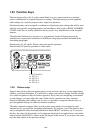
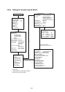
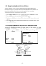
1.35.1
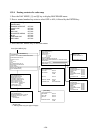
Making a radar map
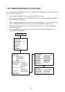
1. Press the NAV MENU key to display the NAV INFORMATION 1 menu.
2. Press [1] key to display the RADAR MAP menu.
3. Press the [2] key twice to set MAP ON, then press the ENTER key.
4. Press the [8] key to select the MAP DISP SELECT menu.
[MAP DISP SELECT]
1 [RADAR MAP]
2 DANGER HIGHLIGHT OFF/ON
3 COAST LINE OFF/ON
4 MARK OFF/ON
5 NAV LINE OFF/ON
6 PROHIBITED AREAS OFF/ON
7 BUOY OFF/ON
8 CONTOUR LINE OFF/ON
9 WPT MARK OFF/ON
5. Press appropriate numeric key twice to select ON, then press the ENTER key.
6. Press the NAV MENU key to close the menu.
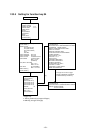
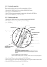
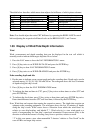
Mark entry mode
Marks can be entered in 3 different ways.
1. Press the NAV MENU to display the NAV INFORMATION 1 menu.
2. Press [1] key to display the RADAR MAP menu.
3. Press [6] key and further press [6] key to select the entry mode - cursor, L/L or own ship
position.
4. Press the ENTER key followed by the NAV MENU key.
5. Press the MARK key to read the following legends.