


39
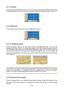
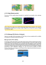
4.6.1.1 Route line
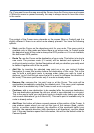
The upper part of this screen shows your planned route as a horizontal line. Its
leftmost point is the start of the route, the rightmost one is the nal destination,
and you can see your via point ags along the line, spaced in proportion to their
distance.
The blue (yellow at night) arrow representing your position will travel from the left to
the right, giving you visual feedback of your journey.
When you reach a via point, it becomes the starting point of the route, the past will be
deleted, the line with all the other via points will be modied instantly, and the arrow
jumps back to the left.
When Uniden Navigation needs to recalculate the route, the arrow will not jump back
to the left as when reaching a via point, but it may drift a bit as the length of the new
route may be different from the previous one.
When the data corresponding to the entire route is displayed in the elds below, the
line is coloured the same way as the route line shown on the map. When you see
data that belongs to a via point, the route is coloured only up to that via point. The
rest of the line remains grey.
4.6.1.2 Distance Left
This value can also be displayed in one of the Route data elds on the Cockpit screen
as ‘Distance to destination’. This is the distance you need to travel on the route before
reaching your nal destination.
If via points exist, tap and tap again any of the elds to see the distance to reach the
rst, second, etc. via point.
4.6.1.3 Method
This eld shows how the route was calculated. It either displays the ‘Route’ or the
‘Vehicle’ eld from the Route parameter settings. If you have chosen Car, Taxi, Bus
or Lorry, the type of the route (Fastest, Shortest or Economical) will be displayed
here; if you have selected Emergency, Bicycle or Pedestrian, this information will be
displayed here.
4.6.1.4 Time Left
This is an estimated value that can also be displayed in one of the Route data elds
on the Cockpit screen as ‘Time to destination’. It shows the time needed to reach
the nal destination of the route based on information available for the remaining
segments of the route. The calculation cannot take into account trafc jams and other
possible delays.
If via points exist, tap and tap again any of the elds to see the time needed to reach
the rst, second, etc. via point.