


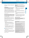
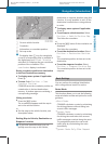
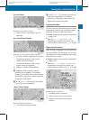
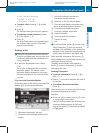

Current Street
Map with road display activated
1
Road name or road number, e.g. for
highways
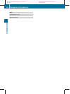
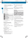
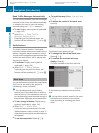
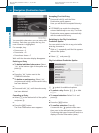
Geo-Coordinates Display
Map with geo-coordinates display activated
1
Current, rounded height above sea level
2
Coordinates display of the current
vehicle location (latitude)
3
Coordinates display of the current
vehicle location (longitude)
4
Number of visible GPS satellites.
i
Adequate GPS reception must be
available for all displays. The altitude
display 1 may differ from actual altitude
because the navigation system calculates
it using the GPS signals.
i
In the Scroll Map function the display
1 and 4 are not displayed.
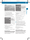
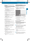
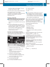
“None” Menu Option
Map with display switched off
1
Currently set map orientation
i
In the Scroll Map function you will see
other data depending on crosshairs
position, for example a road name if the
digital map supports this data.
Topographic Map
You can have the map display enhanced with
topographic features (e.g. mountain ranges,
coloration based on relief information).
X
To set: Display menu system if applicable
(Y page 106).
X
Select Navi £ Topographic Map.
Depending on the previous status, the
function will be switched offcor on Ç.
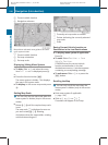
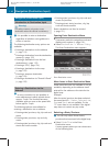
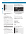
Highway Information
When driving on highways, you can have the
next gas stations, service areas, etc. as well
as the distance to them displayed in the right-
hand half of the screen.
X
To set: Display menu system if applicable
(Y page 106).
X
Select Navi £ Highway Information.
Depending on the previous status, the
function will be switched offcor on Ç.
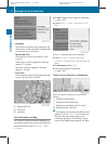
Example display: Function on
1
Available points of interest
2
Name of rest area or exit number
3
Distance from the current vehicle
location
Navigation (Introduction)
111
COMAND APS
BA 197 USA, CA Edition A 2011; 1; 27, en-US
hereepe Version: 3.0.3.5
2010-03-24T15:31:10+01:00 - Seite 111
Z