


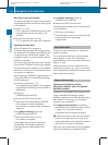
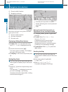
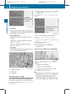

R
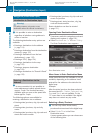
Incidents
Road sections marked by a yellow line =
with arrows: traffic slowdown possible due
to incidents (e.g. road work)
R
Speed and Flow
Road sections marked by yellow or red
cars :.
Yellow cars: Traffic congestion, average
speed 25 – 45 mph.
Red cars: Traffic congestion, average
speed 5 – 20 mph.
R
Free Flow
Road sections marked by a green line with
arrows ;: free flow of traffic.
1
Speed and Flow
2
Free Flow
3
Incidents
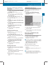
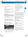
Text Information on Map
You can have map information displayed at
the bottom edge of the screen. By default the
map information is set to Arrival Time/
Distance.
X
To set: Display menu system if applicable
(Y page 106).
X
Select Navi £ Text Information On
Map.
A dot R indicates the current setting.
X
Select Arrival Time/Distance or
Current Street or Geo-coordinates or
None.
X
To exit menu: Slide o m p.
X
Hide menu system if applicable
(Y page 106).
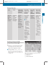
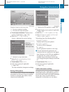
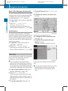
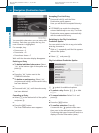
Time of Arrival/Distance to Destination
Map with display activated for time of arrival/
distance
1
Symbol for destination
2
Distance to the destination
3
Symbol for estimated time of arrival
4
Estimated time of arrival
i
This display can only be seen during route
guidance. In the Scroll Map function you
will see other data depending on the
crosshairs position, for example a street
name if the digital map supports this data.
110
Navigation (Introduction)
COMAND APS
BA 197 USA, CA Edition A 2011; 1; 27, en-US
hereepe Version: 3.0.3.5
2010-03-24T15:31:10+01:00 - Seite 110