


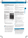
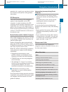
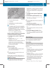
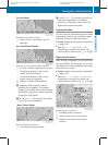

1
Current vehicle location
2
Crosshairs
3
Information on crosshairs position
4
Set map scale
i
The display item 3 may for example be
a road if corresponding data is available in
the digital map and Current Street is
activated. Or it displays the geo-coordinate
position of the crosshairs if Geo-
coordinates display is activated.
Saving crosshairs position as destination
in the Last Destinations memory
X
To display menu system if applicable:
Press n.
X
To save: Select Position £ Save
Crosshair Position.
COMAND saves the crosshairs position as
a destination in the last destinations
memory. A window appears containing a
corresponding message.
Hiding crosshairs
X
Press the k button.
The crosshairs disappear and the map is
set to the vehicle location.
or
X
Set the map to the vehicle location, see
description below.
Setting Map to Vehicle, Destination or
Stopover Location
i
If you have moved the map, you can
quickly move the map to the vehicle,
destination or stopover location using this
function. It is only possible to set it to the
destination location when route guidance
is active.
X
To display menu system if applicable:
Press n.
X
To set map to vehicle location: Select
Position £ Vehicle Position Map.
This hides the crosshairs.
or
X
Press the k button if the crosshairs are
displayed.
This hides the crosshairs.
X
To set the destination location: Select
Position £ Destination Position
Map.
The crosshairs position is then set to the
destination.
X
To set the stopover location: Select
Position £ Stopover Position Map.
The crosshairs position is then set to the
stopover.
Basic Settings
You can perform the settings listed below
with route guidance inactive or active.
Route Mode
This function allows you to set the following
route calculation modes and options for route
guidance:
R
Short Route
COMAND calculates a route by minimizing
the driving distance without taking into
acount traffic messages.
R
Dynamic Route
COMAND calculates a route by minimizing
the driving time and takes into account
traffic messages received along the route.
The navigation system thus can avoid
traffic jams by recalculating the route
dynamically.
R
Dynamic Route Only After Request
Navigation (Introduction)
107
COMAND APS
BA 197 USA, CA Edition A 2011; 1; 27, en-US
hereepe Version: 3.0.3.5
2010-03-24T15:31:10+01:00 - Seite 107
Z