


195
Control systems
COMAND navigation (introduction)
Current street
You can set whether the current street you
are driving on should be displayed in the
map.
̈ Displaying: Select “Navi” Ǟ “Navi” Ǟ
“Map Display”.
The map display list appears. A dot R
indicates the current setting.
̈ Select “Current Street”.
Depending on the previous status the
display showing the current street is
switched on or off.
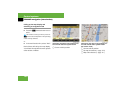
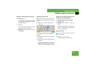
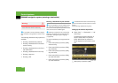
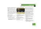
Geo-coordinate display
Illustration: map with geo-coordinate dis-
play switched on
1 Current height above sea level
2 Number of GPS satellites from which
signals for positioning can be received
3 Coordinate display
Display options with geo-coordinate dis-
play switched on
If the crosshair is displayed on the map
view (map was moved manually), only dis-
play 3 is visible.
It shows either the coordinates of the
crosshair or other data on the crosshair
position, e.g. a street name. The digital
map must contain relevant data in order
for this other data to be displayed.
i
There must be sufficient GPS reception for
displays 1, 2 and 3 to be shown. Height dis-
play 1 is an approximation because the naviga-
tion system uses the GPS signals for the
calculation.
i
If there is no crosshair on the map view, dis-
plays 1, 2 and 3 are visible. Display 3
shows the coordinates of the current vehicle po-
sition.