


117
Other features, such as a river or a street intersection will not appear
highlighted, but the cursor will take you to those locations just the
same.
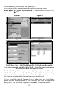
3. Press
MENU|ENT and the unit will begin navigating to the location.
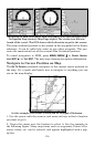
The Map Page will display a dotted line from your current position to the
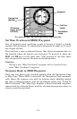
cursor position. The Navigation Page displays a compass rose showing
navigation information to your destination. See the following examples.
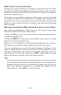
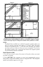
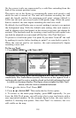
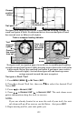
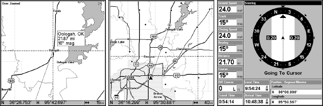
The 15-mile zoom figure clearly shows the dotted course line connect-
ing your current position to your destination (left). The 40-mile zoom
(center) shows both current position and destination on screen. The
Navigation Page (right) will also show navigation information.
To stop navigating to the cursor, use the Cancel Navigation command:
press
MENU|MENU|↓ to CANCEL NAVIGATION|ENT|← to YES|ENT.
Navigate to a Point of Interest
For POIs that are in view on the map, you can easily use the Navigate
to Cursor command above. Just use the cursor to select the POI.
The other method involves searching for POIs with the Find Waypoint
command, launched with the
WPT key. (See the searching example ear-
lier in this section or turn to Sec. 9, Searching, for detailed instructions
on POI searches.)
After you have looked up an item with the Find Waypoint command
make sure the
GO TO WAYPOINT command is highlighted and press ENT.
The unit shows navigation information to the item. To cancel naviga-
tion, press
MENU|MENU|↓ to CANCEL NAVIGATION|ENT|← to YES|ENT.
Creating and Saving a Trail
A trail, or plot trail, is a string of position points plotted by the unit as
you travel. It's a travel history, a record of the path you have taken.
Trails are useful for repeating a journey along the same track. They are
particularly handy when you are trying to retrace your trip and go back
the way you came.