


112
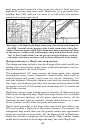
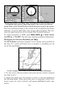
6. The unit's map appears, with the cross-hair cursor highlighting the
restaurant' s POI symbol. A pop-up data box shows the POI's name,
distance and bearing. A data box at the bottom of the screen continues
to display the location's latitude and longitude.
7. To clear the search and return to the last page displayed, press
EXIT
repeatedly. Before you completely exited out of the Search menus, you
could have gone looking for another place.
NOTE:
Search works from mapping and POI data loaded in the unit. If you
do not have a high-detailed custom map (containing POI data) for
the area you are searching loaded on the MMC, you may not find
anything.
Set a Waypoint
A waypoint is an electronic address, based on the latitude and longi-
tude of a position on the earth. A waypoint represents a location or des-
tination that can be stored in memory, then be recalled later for navi-
gational use.
You can create a waypoint at the cursor position on the map or at your
current position while you are navigating. A waypoint may be created
at any location by manually entering the position's latitude and longi-
tude. You can copy waypoints from your unit to your personal computer
with MapCreate software. When you want to repeat a trip, these ar-
chived waypoints can be reloaded into your GPS unit.
To create and save a Waypoint:
These first two techniques use the Quick Save method, the fastest and
easiest way to create a waypoint.
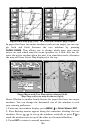
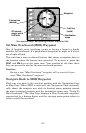
Create Waypoint at Current Position
While you are traveling, press WPT|WPT. The waypoint is saved and
automatically given a name with a sequential number, such as "way-
point 003." The waypoint symbol and number appear on the map.