


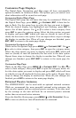

71
To configure a map fix:
To use this format, you need to follow these steps in order. First, take
your map of the area and determine a reference latitude/longitude.
NOTE:
In order for this system to work, the latitude/longitude lines must
be parallel with the edge of the map. USGS maps are parallel, oth-
ers may not be. This works better with smaller scale maps.
The reference position can be anywhere on the map, but the closer it is to
your location, the smaller the numbers will be that you'll have to deal
with. Once you've decided on a reference position, you can save it as a
waypoint. See the waypoint section for information on saving a waypoint.
Save the reference position as a waypoint. Now exit the waypoint screens.
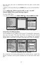
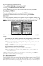
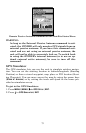
From the Coordinate System menu press ↓ to
SETUP MAP FIX|ENT. The
following screens appear with
MAP SCALE highlighted. Press ENT to input
the map's scale. This, typically, is at the bottom of the paper map. It's
shown as a ratio, like 1:24000. After inputting the map scale, press
ENT.
Configure a map fix so the iFINDER can find your position on a
printed chart or topographical map.
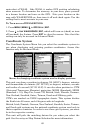
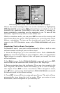
Press ↓ to SELECT ORIGIN|ENT, which will launch the Select Point window
with three options: My Waypoints, Map Places and Highway Exits. If
you saved the reference point as a waypoint, choose
MY WAYPOINTS by
pressing
ENT|ENT, which will bring up the Waypoint list with the way-
point nearest your location at the top. Use the ↓ ↑ keys to select the
waypoint you want to assign as a reference point and press
ENT. The
unit displays a waypoint information screen with the command
SET AS
ORIGIN selected. Press ENT and the unit returns to the Configure Map
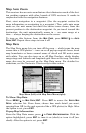
Fix menu. Finally, press
EXIT to close this menu. Now press ↑ to COORD
SYSTEM|ENT, select MAP FIX from the list and press ENT. All position in-
formation now shows as a distance from the reference waypoint you
chose. Press
EXIT repeatedly to return to the map page display.