


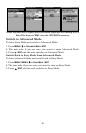
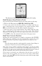

48
The distance to Dallas from the starting point is 211.1 miles.
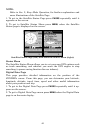
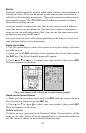
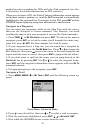
Find Distance from Point to Point
You can also measure distance between two other points on the map.
1. While on the Map page press
MENU|↓ to FIND DISTANCE|ENT.
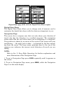
2. Center your cursor over the first position. (A rubber band line ap-
pears, connecting your current position to the cursor's location.) Press
ENT to set the first point and the rubber band line disappears.
3. Move the cursor to the second position. The rubber band line reap-
pears, connecting the first point you set to the cursor. The distance
along that line will appear in the lower right-hand corner of the screen.
4. Press
EXIT to clear the command and return to the page screen.
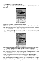
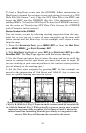
Find Your Current Position
Finding your current position is as simple as turning on the iFINDER.
Under clear sky conditions, the unit automatically searches for satel-
lites and calculates its position in approximately one minute or less.
NOTE:
Clear sky means open sky, unobstructed by terrain, dense foliage or
structures. Clouds do not restrict GPS signal reception.
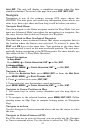
If for some reason satellite acquisition takes longer, you may be inside
a structure or vehicle or in terrain that is blocking signal reception. To
correct this, be sure you are positioned so the unit has as clear a view of
the sky as possible, then turn the unit off and back on again.
If the cursor is activated, any information the unit gives you will be
based on the cursor position, not your own. If you want to find where
you are, just press
EXIT until the cursor goes away and the map snaps
back to your position.