


57
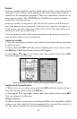
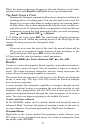
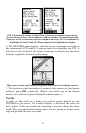
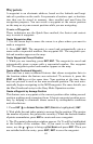
POI information screen on fast food restaurant nearest this position.
Screen shows name, street address, phone number, latitude/longitude,
distance to the restaurant and its compass bearing. Go To command is
highlighted (left). Find On Map command is highlighted (right).
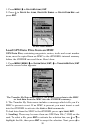
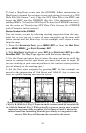
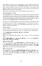
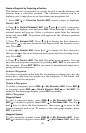
6. The iFINDER's map appears, with the cursor crosshairs centered on
the restaurant's POI symbol. A pop-up name box identifies the POI. A
data box at the bottom of the screen continues to display the location's
latitude, longitude, distance and bearing.
Map screen showing Finding Waypoint the result of a lodging search.
7. To clear the search and return to return to the current or last known
position, press
EXIT repeatedly. (Before you exited out of the Search
menus, you could have gone looking for another place.)
Trails
A trail, or plot trail, is a string of position points plotted by the
iFINDER as you travel. It's a travel history, a record of the path you
have taken. Trails are useful for repeating a journey along the same
track. They are particularly handy when you are trying to retrace your
trip and go back the way you came.