


Garmin G1000 Cockpit Reference Guide for the Mooney M20M, M20R, & M20TN
10-12
SECTION 10 – HAZARD
AVOIDANCE
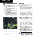
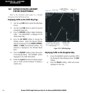
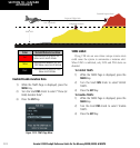
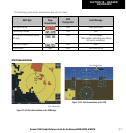
Potential Impact Point
Unlighted Obstacle
Projected Flight Path
1000' AGL
100' Threshold
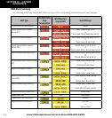
Color Terrain/Obstacle Location
Red
Terrain/Obstacle at or within 100’
below current aircraft altitude.
Yellow
Terrain/Obstacle between 100’ and
1000’ below current aircraft altitude.
Black
Terrain/Obstacle is more than 1000’
below aircraft altitude.
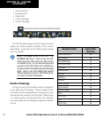
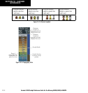
Enable/Disable Aviation Data
1) While the TAWS Page is displayed, press the
MENU
Key.
2) Turn the
Small FMS
Knob to select “Show (or
Hide) Aviation Data”.
3) Press the
ENT
Key.
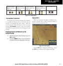
Figure 10-19 TAWS Page Menu
TAWS Inhibit
Flying VFR into an area where unique terrain exists
could cause the system to annunciate a nuisance alert.
When TAWS is inhibited, only FLTA and PDA alerts are
disabled.
To Inhibit TAWS:
1) While the TAWS Page is displayed, press the
MENU
Key.
2) Turn the
Small FMS
Knob to select‘Inhibit
TAWS’.
3) Press the
ENT
Key.
To Enable TAWS:
1) While the TAWS Page is displayed, press the
MENU
Key.
2) Turn the
Small FMS
Knob to select ‘Enable
TAWS’.
3) Press the
ENT
Key.