


Garmin G1000 Cockpit Reference Guide for the Mooney M20M, M20R, & M20TN
10-11
SECTION 10 – HAZARD
AVOIDANCE
10.7 TERRAIN AWARENESS & WARNING
SYSTEM (TAWS) DISPLAY
(OPTIONAL)
NOTE: Terrain data is not displayed when the
aircraft latitude is greater than 75 degrees north
or 60 degrees south.
NOTE: TAWS operation is only available when the
G1000 is configured for a TAWS-B installation.
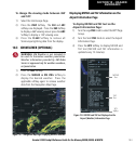
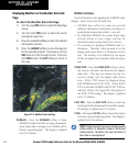
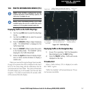
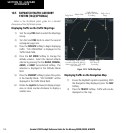
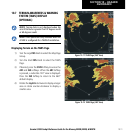
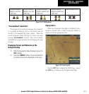
Displaying Terrain on the TAWS Page
1) Turn the
Large FMS
Knob to select the Map Page
Group.
2) Turn the
Small FMS
Knob to select the TAWS
Page.
3) If desired, press the
VIEW
Softkey to access the
ARC
and
360
softkeys. When the
ARC
Softkey
is pressed, a radar-like 120° view is displayed.
Press the
360
Softkey to return to the 360°
default display.
4) Rotate the
Joystick
clockwise to display a larger
area or rotate counter-clockwise to display a
smaller area.
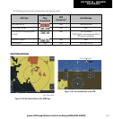
Figure 10-17 TAWS Page (360˚ View)
Figure 10-18 TAWS Page (ARC View)