


Garmin G1000 Cockpit Reference Guide for the Mooney M20M, M20R, & M20TN
10-5
SECTION 10 – HAZARD
AVOIDANCE
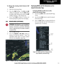
CELL MOV – Pressing the CELL MOV Softkey shows
storm cell movement by displaying an arrow.
pointing in the direction of predicted movement.
The display is updated every 12 minutes.
SIG/AIR – Pressing the SIG/AIR Softkey shows
SIGMET and AIRMET information.
The display is
updated every 12 minutes.
METAR – Press the METAR Softkey to graphically
display METARs. METARS are shown as colored
flags at airports providing METAR reports. The
display is updated every 12 minutes.
MORE WX – Press the MORE WX Softkey to display
the following group of softkeys for additional
weather control:
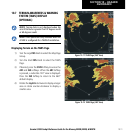
SFC – Pressing the SFC Softkey for Surface Analysis
shows current or forecast conditions. Forecasts
are available for intervals of Current, 12, 24, 36,
and 48 hours. Press the softkey corresponding
to the desired forecast. The closest city forecast
information is displayed in the legend. The
display is updated every 12 minutes.
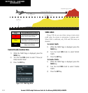
FRZ LVL – Press the FRZ LVL Softkey to display
contour lines for freezing levels.
The display is
updated every 12 minutes.
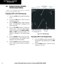
WIND – Press the WIND Softkey to show wind
speed and direction at a selected altitude from
the ground up to 42,000 feet in 3,000 foot
increments. After pressing the
WIND Softkey,
press the softkey corresponding to the desired
winds aloft altitude. The display is updated every
12 minutes.
COUNTY – Pressing the COUNTY Softkey provides
specific public awareness and protection
weather
warnings for Tornado, Severe Thunderstorm,
and Flood conditions provided by the National
Weather Service (NWS). The display is updated
every 5 minutes.
CYCLONE – Pressing the CYCLONE Softkey shows
the current location of cyclones (hurricanes and
tropical storms) and their projected track at
various time intervals.
The display is updated
every 12 minutes.
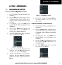
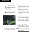
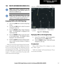
Map Panning Information – Weather Data Link
Page
1) Push in the
Joystick
to display the panning
arrow.
2) Move the
Joystick
to place the panning arrow
on AIRMETs, TFRs, METARs, or SIGMETs. Press
the ENT Key to display pertinent information
for the selected product.
Pressing the
ENT Key when panning over an
AIRMET or a SIGMET displays an information
box that displays the text of the report. Panning
over an airport with METAR information does
not display more information but allows the
user to press the ENT Key and select that
Airport’s Information Page to display the text
of the report. Pressing the ENT Key when
panning over a TFR displays TFR specific
information.
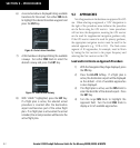
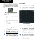
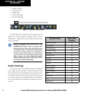
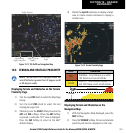
Weather Products and Symbols
Figure 10-10 depicts the symbol for each weather
product (read from left to right). When a weather product
is active, the product symbol is displayed in the lower
right of the screen.
• NEXRAD
• Cloud Top/Echo Top
• XM Lightning
• Cell Movement
• SIGMETs/AIRMETs
• METARs
• City Forecast