


Garmin G1000 Cockpit Reference Guide for the Mooney M20M & M20R
10-9
SECTION 10 – HAZARD
AVOIDANCE
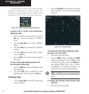
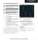
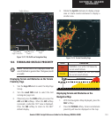
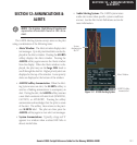
Figure 10-13 TAS Traffic on Navigation Map
Traffic Advisory
Traffic Off Scale
Banner
Non-Bearing
Traffic Advisories
Non-Threat
Traffic
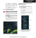
10.6 TERRAIN AND OBSTACLE PROXIMITY
NOTE: Terrain data is not displayed when the
aircraft latitude is greater than 75 degrees (north
or south).
Displaying Terrain and Obstacles on the Terrain
Proximity Page
1. Turn the
large FMS
knob to select the Map Page
Group.
2. Turn the
small FMS
knob to select the last
rectangular page icon.
3. If desired, press the
VIEW
softkey to access the
ARC
and
360
softkeys. When the
ARC
softkey
is pressed, a radar-like 120° view is displayed.
Press the
360
softkey to return to the 360°
default display.
4. Rotate the
Joystick
clockwise to display a larger
area or rotate counter-clockwise to display a
smaller area.
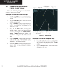
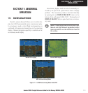
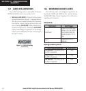
Figure 10-14 Terrain Proximity Page
Color Indication
RED
WARNING: At or within 100’ below the
current aircraft altitude.
YELLOW
CAUTION: Between 100’ and 1000’ below
the current aircraft altitude.
1000' AGL
Aircraft Altitude
100' Threshold
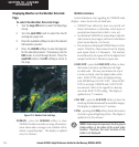
Displaying Terrain and Obstacles on the
Navigation Map
1. With the Navigation Map displayed, press the
MAP
softkey.
2. Press the
TERRAIN
softkey. Terrain and obstacle
proximity will now be displayed on the map.