


Garmin G1000 Cockpit Reference Guide for the Mooney M20M & M20R
1-4
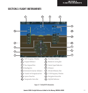
SECTION 1
SYSTEM OVERVIEW
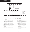
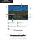
1.2 PFD SOFTKEYS
Softkey OFF
Softkey ON
OBS
TMR/REF
NRST
INSET
IDENT
XPDR
CDI
PFD
ALERTS
ADF/DME
(optional)
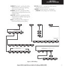
Figure 1-2 PFD Top Level Softkeys
INSET – Press to display the Inset Map in the lower
left corner of the PFD.
OFF
– Press to remove the Inset Map
DCLTR
(3) – Press momentarily to select the
desired amount of map detail. The declutter
level appears adjacent to the DCLTR softkey.
• No declutter: All map features are visible
• Declutter – 1: Declutters land data
• Declutter – 2: Declutters land and SUA data
• Declutter – 3: Declutters large NAV data remaining
(removes everything except the active flight plan)
TRAFFIC
– Press to display TIS traffic on the map.
TOPO
– Press to display topographical data (i.e.,
coastlines, terrain, rivers, lakes, etc.) and
elevation scale on the inset map.
INSET
OFF
TOPO
TRAFFIC
TERRAIN
DCLTR
DCLTR-2
DCLTR-3
DCLTR-1
NEXRAD
Press the BACK or OFF softkey
to return to the top leve
l
softkeys
XM LTNG
STRMSCP
BACK
ALERTS
(optional) (optional)(optional)
Figure 1-3 PFD Softkey Flow Chart – 1
TERRAIN
– Press to display terrain information
on the inset map.
STRMSCP (optional)
– Press to display the Storm-
scope lightning data on the inset map (within
a 200 nm radius of the aircraft).
NEXRAD (optional)
– Press to display NEXRAD
precititation data on the inset map.
XM LTNG (optional)
– Press to display the XM
Radio lightning data on the inset map.
BACK
– Press to return to the previous level
softkey configuration.
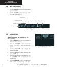
PFD – Press to display the additional softkeys for
additional configurations to the PFD.
METRIC
– Press to display the current and refer-
ence altitudes in meters, in addition to feet.
Pressing the metric softkey also changes the
barometric setting to hectopascals.
DFLTS
– Press to reset default settings on the PFD.
DME
(optional) – Press to display the DME informa-
tion window.
BRG1 (bearing)
– Press to cycle through the follow-
ing Nav sources, making the pointer the indica-
tor for the corresponding source and displaying
the the appropriate information.