


Garmin G1000 Cockpit Reference Guide for the Mooney M20M & M20R
10-4
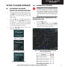
SECTION 10 – HAZARD
AVOIDANCE
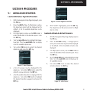
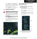
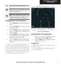
Displaying Weather on the Weather Data Link
Page
To select the Weather Data Link Page:
1. Turn the
large FMS
knob to select the Map Page
Group.
2. Turn the
small FMS
knob to select the fourth
rectangular page icon.
3. Press the available softkeys to select the desired
XM weather product.
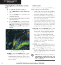
4. Press the
LEGEND
softkey to view the legends
for the selected products. If necessary, turn the
FMS
knobs to scroll through the list. Press the
small FMS
knob or the
ENT
softkey to return to
the map.
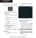
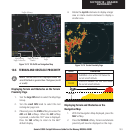
Figure 10-9 Weather Data Link Page
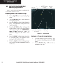
NEXRAD – press the NEXRAD softkey to show
NEXRAD weather and radar coverage information.
Areas where radar coverage is not available will be
shown in grayish-purple. The display is updated
every five minutes.
NEXRAD Limitations
Certain limitations exist regarding the NEXRAD radar
displays. Some, but not all, are listed here:
• NEXRAD base reflectivity does not provide suf-
ficient information to determine cloud layers or
precipitation characteristics (hail vs. rain, etc).
• An individual NEXRAD site cannot depict high alti-
tude storms at close ranges, and has no information
about storms directly over the site.
• The resolution of displayed NEXRAD data is 2 kilo-
meters. Therefore, when zoomed in on the display,
each square block is 2 kilometers. The intensity
level reflected by the square will be the highest level
sampled within the 2 kilometer square area.
ECHO TOP – press the ECHO TOP softkey to show
the location, elevation, and direction the high-
est radar echo. This may not indicate the top of
a storm or clouds, only the highest radar return
echo. ECHO TOPS cannot be displayed along
with NEXRAD and CLOUD TOPS. When ECHO
TOPS is activated, NEXRAD and CLOUD TOPS
are removed. Refer to the Legend for a descrip-
tion of the ECHO TOPS coding. The display is
updated every 7.5 minutes.
CLD TOP – press the CLD TOP softkey to show the
cloud top altitude determined from satellite imagery.
The display is updated every 15 minutes.
LTNG – pressing the LTNG softkey shows the location
of cloud-to-ground lightning strikes. The display is
updated every five minutes.
NOTE: Strikes depicted represent cloud to ground
strikes within a 2 km radius of the actual strike
location. Therefore, the exact location of the
strike is not displayed.