


28 Quest Owner’s Manual
USING THE MAIN PAGES > MAP PAGE
USING THE MAIN PAGES
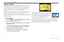
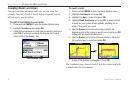
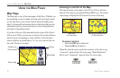
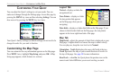
Map Page
The Map page is one of the main pages of the Quest. Whether you
are navigating a route or simply traveling with your Quest turned
on, the map shows your current location and surrounding street
detail. Customizable information boxes called data fields provide
information such as your current speed, your traveling direction,
and names of upcoming streets.
A text bar at the top of the map indicates the status of the Quest’s
GPS receiver. When you turn on your Quest, the text bar indicates
that the Quest is attempting to locate satellites. After the Quest
locates satellites and establishes a “fix” on your location, the text
bar reads “Ready to Navigate.”
Data fields
Text barPosition icon
(You are here)
Zoom range
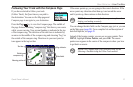
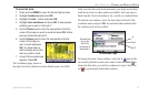
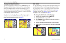
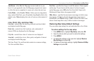
Zooming In and Out of the Map
The map has many zoom ranges, from 20 ft to 500 mi. Zoom in
and out of the map by pressing the IN and OUT keys. The current
zoom range is displayed at the bottom left corner of the map.
Base map
at 5-mile zoom
MapSource (detailed) map
at 500-foot zoom
To zoom in and out:
• Press the OUT key to zoom out.
• Press the IN key to zoom in.
When the selected zoom exceeds the resolution of the data in use,
“overzoom” appears below the zoom range. When MapSource
®
data is used, “mapsource” appears below the zoom range.