


3. PLOTTER OPERATION
3-13
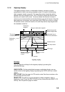
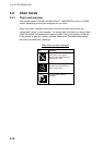
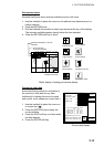
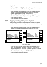
Port service icons
Selected NavCharts show services available at ports, with icons.
1. Use the trackball to place the cursor on the sailboat icon (denotes a port or
harbor) desired.
2. Push the [ENTER] knob.
3. Roll the trackball horizontally to select icon desired at the top of the display.
The services available appear directly below the icon selected.
4. Press the RETURN soft key to finish.
34° 22. 3456'N 359.9°
M
TRIP
NU
080° 22. 3456'E
19.9 kt 99.9 nm
Emergency
medical service
Water
supply station
Customer
service station
Information center
Fueling station
Traveler's
service station
Marine
equipment service
Port
CANCEL
FIRST AID
Sailboat icon (Port)
Detailed information of service
selected
List of services
at the port selected
16.0nm
Plotter display, showing port service display
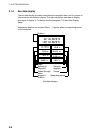
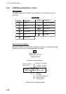
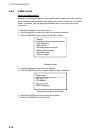
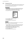
Current (or tide) data
Some NavCharts provide for calculation of
the current (or tide) data for any date.
Additionally it displays the time of sunrise
and sunset, moon shape (on current data.)
1. Use the trackball to place the cursor on
a current icon (
).
2. Press the [ENTER] knob to show the
current window.
3. Press the DATE soft key, and then enter
the date desired.
4. Press the ENTER soft key.
Current data display
34 24. 3456 N 359.9 NU
124 24. 3456 W 59.9kt 024nm
+
Time: 04:35
Speed (KT): 0.45ft
Angle ( ): 142
21/08/02 +00
Moonphase: FULLY IN 1 DAY
Sunrise: 05:03 Moonrise: 14:06
Sunset: 19:10 Moonset: 02:15
0.86
0.74
0.61
0.48
0.35
048
12
16 2024
RETURN
DATE
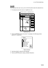
Current
Max. Time Speed Aug. Slack
KT AT
Flood 4:58 1.2 323 7:58
Ebb 23:15 1.2 323 20:15
Flood 17:15 1.1 145 15:15
Ebb 23:15 1.2 323 20:15