


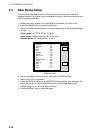

5. CUSTOMIZING YOUR UNIT
5-17
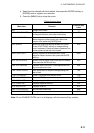
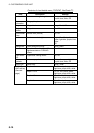
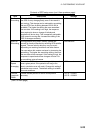
Contents of chart details menu for C-MAP (con’t from previous page)
Item Description Settings
Bathymetric Line Plotter/Overlay, Plotter, Off
Spot Sounding Plotter/Overlay, Plotter, Off
Bottom Type Plotter/Overlay, Plotter, Off
Depth Area Limit 0-99999 ft (m, fa, P/B)
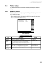
DEPTH INFO
soft key
(See below.)
Bathymetric Range 0-99999 ft (m, fa, P/B)
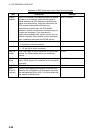
Settings description
Basic: Shows basic characteristics of objects.
Detailed: Shows detailed characteristics of objects.
Multiple: Shows multiple icons for complex objects.
Off: Turns item off.
On: Turns item on.
Plotter: Shows item on plotter display.
Plot/No Sector: Shows item on plotter display. Sector not shown.
Plotter/Contour: Shows contour on plotter display.
Plotter/Overlay: Shows item on plotter and overlay displays.
Single: Shows single icon for complex objects.
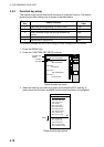
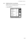
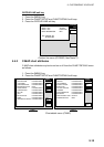
DEPTH INFO soft key
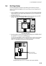
1. Press the [MENU] key.
2. Press the CHART SETUP and
CHART DETAILS soft keys.
3. Press the DEPTH INFO soft key.
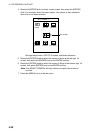
Note: The bathymetric range setting
allows you to control the color (Dark
blue, light blue or white) associated
to user assigned depths. Any
contour line area that contains a
depth that is LOWER than the first
number will be shown in dark blue.
Any contour line area that contains a depth
BETWEEN the first and second number will be shown as light blue. Any contour
line area that contains a depth that is HIGHER than the second number will
be white. For example, if the bathymetric range setting is set to 00010~00050 ft,
all contour areas that contain any depth less than 10 ft deep would be shaded
dark blue, all depth contour areas that contain a depth between 10 and 50 feet
will be shaded light blue, and all contour areas over 50 feet deep will be white.
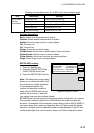
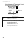
DEPTH
INFO
EDIT
RETURN
BATHYMETRIC LINE PLOTTER/OVERLAY
SPOT SOUNDING PLOTTER/OVERLAY
BOTTOM TYPE PLOTTER/OVERLAY
DEPTH AREA LIMIT 00020, 00164ft
BATHYMETRIC RANGE 00000-00033ft
Depth info menu (C-MAP)