


3. PLOTTER OPERATION
3-17
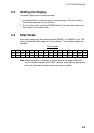
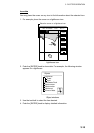
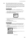
34 24. 3456 N 359.9 NU
124 24. 3456 W 59.9kt 024nm
+
Time: 04:35
Height: 0.45ft
Draught: 0.65ft
28/10/98 -05
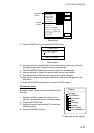
43° 32.860N
010° 18.022E
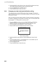
Port information
LIVORNO (LEGHORN)
High Water(max) 0.86ft(13:30 L)
Low Water(min) 0.35ft(21:00 L)
Sunrise 07:52L
Sunset 16:53 L
0.86
0.74
0.61
0.48
0.35
048
12
16 20 24
RETURN
DATE
Vertical
Cursor
Horizontal
Cursor
TIDE
Tide window
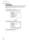
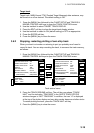
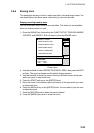
5. Press the DATE soft key to open the DATE window.
CHANGE DATE
(DAY. MONTH. YEAR)
2 8. 10. 1998
LIMIT: 31.12.2099
Date window
6. Use the trackball to position the cursor where desired, then enter date with
the alphanumeric keys. Repeat to enter complete date.
7. Push the [ENTER] knob to show the tidal graph for entered date.
8. Use the trackball to locate the vertical cursor on the hour desired.
9. Use the trackball to shift the horizontal cursor to select draught.
10. See the time, height and draught indications in left of the tide graph for tide
information.
11. Press the CANCEL soft key twice to close the TIDE window.
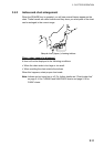
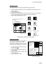
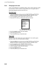
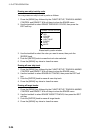
Port service icons
Selected C-MAP shows services available at ports,
with lists.
1. Use the trackball to place the cursor on the
sailboat icon (denotes a port or harbor) desired.
2. Push the [ENTER] knob.
3. Select the service name desired. The services
available appear.
4. Press the CANCEL soft key.
C-map, port service display
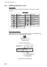
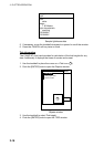
Objects
Port area
Port/Marine
Fuel station
Water
Electricity
Showers
Pubric toilets
Pubric telephone