


3. PLOTTER OPERATION
3-2
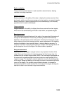
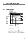
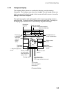
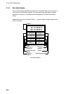
Nav data window
The data shown in the nav data window depends on the status of the NAV soft
key and the cursor.
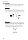
359. 9°
M
359. 9 °
M
79. 9°F NU
19. 9kt 99. 9nm 345 ft
Bearing to Waypoint
Course, Speed
Range
to
Waypoint
Water Temp.*,
Depth*
CSE
SOG
BRG
RNG
TMP
DPT
NAV
S/C
soft key
Presentation
Mode
Own Ship Mark Speed
Trip Distance
NAV
POS
soft key
34°24. 3456'N 359. 9°
M
TRIP NU
124°24. 3456'W 19. 9kt 99. 9nm
CourseLatitude, Longitude
Presentation
Mode
Own ship
position
Own ship
speed and
course
NAV
OFF
soft key
Turns off
nav data
window
* Requires appropriate
sensor.
34°24. 3456'N 359. 9°
M
TRIP NU
124°24. 3456'W 59.9nm 99. 9nm
Bearing to Cursor
Latitude, Longitude
Trip Distance
Presentation
Mode
+
Cursor Mark
Latitude and longitude
of cursor intersection
Range to
Cursor
359. 9°
M
TTG
4D02H23M NU
19. 9nm
ETA
1st 13:45
Bearing to WaypointWaypoint Name
Estimated Time of
Arrival
Range to Waypoint
Waypoint Mark
001WPT
Presentation
Mode
NAV
WPT
soft key
Destination
waypoint
data
Time-to-Go
to Destination
359. 9°
M
359. 9°
M
TRIP NU
19. 9nm 19. 9kt 99. 9nm
CourseBearing to WaypointWaypoint Name
001WPT
Waypoint data
(waypoint selected
with cursor)
Presentation
Mode
SpeedRange to WaypointWaypoint Mark Trip Distance
Contents of nav data window