


73
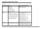
Appendix A: Page Function Table
This table provides an overview of what you can view/do on each page, as well as each page’s menu
functions:
With this Page... You Can... And Use the Page’s MENU to...
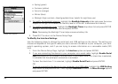
Satellite View the:
•GPSStatus
•WAASStatus
•GPSaccuracy
•Satelliteconstellation
•Satellitesignalgraph
•Batteryindicator
•Disable/EnableGPS
•Setthecurrentlocation
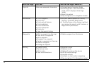
Map View:
•Varioustypesofmapdata
•Thescaleforthecurrentmap
•TheNortharrow(onlyavailable
when Heading Up is selected as
the map orientation and the
map is not Course or North Up)
•YourcurrentGPSstatus
•Yourdirectionoftravel
•Turnimageryonoroff
•Show/hide/arrange/change/restore
information fields
•Measurethedistance/areaofauser-
drawn line/polygon
•Show/hidemappackages
•Layermapdata
•Changethemaporientation
•ChangethelevelofPOIdetail
•Show/hidewaypoints
•UsesmallPOIsymbolsonthemap
•Changethemapscaletype
•Stopnavigation(ifinNavigationmode)
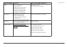
Compass View heading/bearing information •ChangetheDirectRouteArrow
•Hide/arrange/changeinformationelds
•Stopnavigation(ifinNavigationmode)