


15
and wants to use his Earthmate GPS PN-20 to mark a waypoint at the bird location.
10. While at the spot of the tree, press the Mark button.
11. Scroll to the top of the Waypoints screen to highlight the waypoint symbol and press ENTER.
Use the arrow keypad to find and highlight the bird icon and press ENTER.
12. Scroll to the label text field (to the right of the bird icon) and press ENTER. Use the arrow key
pad to highlight the letter E and press ENTER. Repeat this step for each letter in the word
“Eagle.” When you’re finished, highlight OK and press ENTER.
13. Scroll to highlight the Save button and press ENTER.
When he arrives at the desired bird watching spot, he saves his track log, turns off the GPS device,
and spends the day bird watching.
14. Press MENU, select Tracks, and press ENTER.
15. Scroll to highlight the Save button and press ENTER.
16. Press the Power button to turn off the Earthmate GPS PN-20. Press ENTER when prompted.
When he’s finished for the day, he turns the GPS device back on, waits until he gets a 2-D or 3-D fix,
and then follows his track to where he started—ensuring he won’t get lost. The process of following
his initial track creates a new route that he can use to navigate back to the parking lot.
17. Press and hold the Power button to turn on the Earthmate GPS PN-20.
18. Press MENU, select Tracks, and press ENTER.
19. Select the track that was saved earlier that day and press ENTER.
20. Scroll to highlight the Follow button and press ENTER.
Tom follows the route directions on the map screen and reaches his start location without getting lost.
Mountain Biking
TheEarthmateGPSPN-20isalsoaperfectcompanionwhilemountainbiking.
Carla and Jordan are preparing for a ride at Slickrock Bike Trail. Before they go, they download data of
the Moab, Utah, region with their compatible DeLorme software program. They create a route that
starts and finishes at the trailhead and includes three stops: Shrimp Rock, Upper Shrimp Rock, and
Mt. View Cave. Then they export the data of the region, as well as the route they created, to their
Earthmate GPS PN-20. Once they arrive at the trail, they mount their GPS devices onto their bikes,
Scenarios
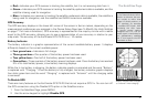
Markingthe“Eagle”waypoint