


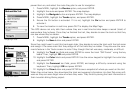

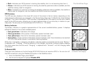
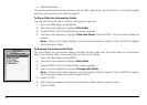

21
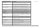
• Red—Indicates your GPS receiver is tracking the satellite, but it is not receiving data from it.
• Green—Indicates your GPS receiver is tracking the satellite, ephemeris data is available, and the
satellite is being used for navigation.
• Blue—Indicates your receiver is tracking the satellite, ephemeris data is available, the satellite is
being used for navigation, and the satellite has WAAS corrections available.
GPS Accuracy
The GPS accuracy displays in the lower-left corner of the screen in feet or meters, depending on the
measurement preferences you assigned in the Device Setup Page (see ToModifytheUnitsSettings
on page 71 for more information). GPS accuracy is represented on the map by a circle with a radius
equal to the GPS accuracy, allowing you to see a representation of your accuracy in relation to your
map scale. The accuracy of the Earthmate GPS PN-20 is +/- 10 meters.
Battery Indicator
The battery indicator is a graphic representation of the current available battery power. It displays
differently based on the current available power:
• Four green bars—Indicates a full charge.
• Three green bars—One quarter of the battery power has been used.
• Two yellow bars—One half of the battery power has been used.
• One red bar—Three quarters of the battery power has been used. Once the battery has reached
5% of its total battery power, a low battery warning displays.
While the Li-Ion battery is charging, the battery indicator graphic is animated and the word “Battery”
is replaced with “Charging.” Once the battery is fully charged, the battery indicator graphic displays
four static green bars and the word “Charging” is replaced with “External” until the charging cable
is removed.
To Disable GPS
There are many features on the Earthmate GPS PN-20 that do not require a GPS fix. You can turn off
the GPS connection using the Disable GPS option in the Satellites menu.
1. From the Satellites Page, press MENU.
2. Use the arrow keypad to highlight Disable GPS.
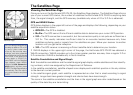
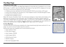
The Satellites Page
Batteryindicatorlabelchanges
to“external”whencharging
Note: WAAS was developed
bytheFederalAviationAdmin-
istrationtoenhancetheaccu-
racy—usually to within three
meters ofactual position—of
GPS receivers by providing
a modiedGPS signal.After
calculating the error factor
at ground control stations
throughout theU.S., the cor-
rectedsignalistransmittedto
two geostationary satellites
thatinturntransmit theGPS
signalbacktoEarth.