


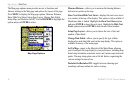

50 GPSMAP 176/176C Owner’s Manual
MAIN MENU > GPS TAB
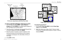
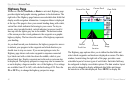
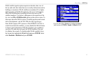
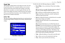
GPS Tab
The GPS tab provides a visual reference of satellite acquisition,
receiver status, and position accuracy. The status information shows
what the receiver is doing at any given moment. The sky view and
signal strength bars give an indication of what satellites are visible
to the receiver and whether or not they are being tracked. The signal
strength is shown on a bar graph for each satellite, with the satellite
number below. As the receiver locks onto satellites, a signal strength
bar appears for each satellite in view, with the appropriate satellite
number underneath each bar.
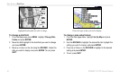
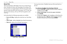
The progress of satellite acquisition is shown in three stages:
• No signal strength bars—the receiver is looking for the
satellites indicated.
• Light signal strength bars—the receiver has found the
satellite(s) and is collecting data.
• Dark signal strength bars—the receiver has collected the
necessary data and the satellite(s) are ready for use.
As soon as the GPSMAP 176/176C has collected the necessary data
from the best satellites in view to calculate a fix, the status field
indicates 2D or 3D status. The unit then updates the position, date,
and time.
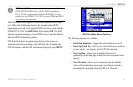
You can use the sky view to help determine whether any satellites
are being blocked, and whether you have a current position fix
(indicated by a 2D, 2D Differential, 3D, or 3D Differential in the
status field). The sky view shows a bird’s-eye view of the position of
each satellite relative to the receiver’s last known position. The outer
circle represents the horizon (north up), the inner circle 45º above the
horizon, and the center point a position directly overhead. You can
also set the sky view to a Track Up configuration, causing the top of
the sky view to align along your current track heading.
WAAS Capability
The GPSMAP 176/176C is capable of receiving WAAS (Wide Area
Augmentation System) satellite signals. WAAS is an FAA (Federal
Aviation Administration) funded project to improve the overall
accuracy and integrity of the GPS signal for aviation use, but land/sea
based users may also benefit from this system. At this time, the
system is still in the development stage and is not fully operational.
There are currently two WAAS satellites that can be received in the
U.S.A., one over the Atlantic Ocean and one over the Pacific Ocean,
in a geostationary orbit over the equator. Effective use of the WAAS
satellite signal may be limited by your geographic location in relation
to those satellites, now in developmental service.