


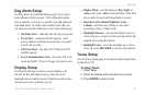

58 Astro Dog Tracking System Owner’s Manual
SettInGS
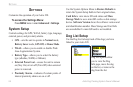
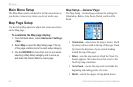
Map Setup – Information Page
The Map Setup –Information page shows a list of
downloaded detailed maps such as topographic, marine
charts, and MapSource maps with auto-routing capability.
Use the ROCKER to select a map, and press ENTER to
show it on the map display or turn it off.
Press MENU to view the options for displaying maps.
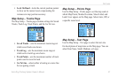
Map Setup – Marine Page
Use the Map Setup –Marine page to customize settings for
marine colors, spot soundings, light sectors, and symbol
sets when using downloaded marine charts (MapSource
BlueChart marine mapping data).
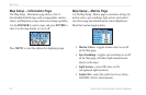
Marine Colors—toggles marine colors on or off
on the Map page.
Spot Soundings—toggles spot soundings on or off
on the Map page. (Periodic depth measurements
shown on the map.)
Light Sectors—select Off, Auto, or ON.
(navigational light locations)
Symbol Set—select the symbol set to use (Auto,
GARMIN, NOAA, International).
•
•
•
•