


20 Astro Dog Tracking System Owner’s Manual
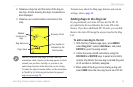
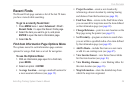
Map paGe
Map paGe
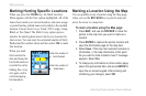
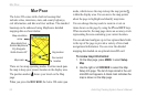
The Astro 220 comes with a built-in basemap that
includes cities, interstates, state, and county highways,
exit information, and lake and river outlines. The standard
basemap can be enhanced using MapSource detailed
mapping data as shown below.
Map orientation
arrow
Map scale
Your current
location
Dog location
Map details from
Garmin MapSource
City Navigator
North America NT
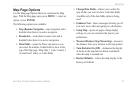
There are two map operating modes. Position mode pans
the map to keep your present location in the display area.
The position marker shows your travel on the Map
page.
When you press the ROCKER, the Astro 220 enters pan
mode, which moves the map to keep the map pointer
within the display area. You can move the map pointer
about the page to highlight and identify map items.
You can change the map scale to zoom in or out on
items shown on the page by using the IN and OUT keys.
When zoomed in, the map page shows an accuracy circle
representing the area containing your current location.
You can add and congure up to four optional data elds
to the top of the page to provide a variety of travel and
navigational information. You can view the detailed
mapping data loaded on an optional microSD card.
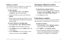
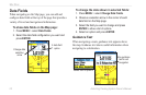
To review map information:
1. On the Map page, press MENU > select Setup
Map.
2. Use the right or left ROCKER to select the Map
Setup Info page. The list of maps stored in the unit
microSD card appears. A check mark indicates the
map is shown on the Map page.