


Astro
Dog Tracking System Owner’s Manual 39
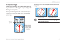
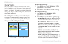
GpS appLIcatIonS
To reset the elevation data and max elevation
elds:
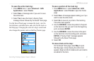
1. Press MENU > select Reset to open the Reset
page.
2. Use the ROCKER to select the reset options, and
then press ENTER to place a check mark in the
box next to a selected item.
3. Select Apply to reset the data elds. A conrmation
message appears.
You can reset or delete data for any of the other
features represented on the list by placing a check
mark in the box next to the item.
4. Select OK to reset the selected options.
5. To reset all categories shown on the page, select
Select All.
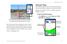
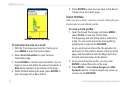
Calibrating the Altimeter
The Astro 220 relies on the barometric pressure to
determine elevation. Since the pressure at any given
elevation can uctuate, you can calibrate the altimeter
to increase its accuracy if you know the elevation or
pressure at your current location.
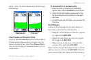
To manually calibrate the altimeter:
1. Press MENU > select Calibrate Altimeter to open
the Calibration page.
2. At the message “Do You Know The Correct
Elevation?” select Yes, or if you do not know the
elevation, select No to use the pressure option. If
you do not know the pressure, select No to use the
default GPS elevation.
3. E
nter the new elevation or pressure > select OK.
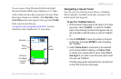
Changing the Data Fields
The Altimeter page has two data elds that you can
customize.
To change a data eld:
1. Press MENU > select Change Data Fields >
select a data eld to view a list of available data
eld options.
2. Select an option to place it in the data eld.