


82 GPSMAP 60CSx Owner’s Manual
MAIn Menu > ProxIMIty wAyPoInts - cAlendAr
K values—denes the wind drag values for
parachutes.
HAHO—(High Altitude High Opening) describes a
type of jump.
HALO—(High Altitude Low Opening) describes a
type of jump.
HARP—(High Altitude Release Point) describes the
location at which the jumper exits from aircraft.
MSL—(Mean Sea Level) denes the basis for altitude
measure.
Opening Altitude—describes the altitude when the
jumpmaster opens his chute, measured in AGL.
PRP—(Primary Release Point) denes the
combination of HARP plus the forward throw of
aircraft.
Static Jump—describes a type of jump in which
wind speed and direction are assumed constant for the
duration of the jump.
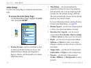
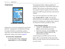
Proximity Waypoints
Use the Proximity Waypoints Page to dene an alarm
circle around a stored waypoint location. The alarm
circle can help you avoid restricted locations.
For more information on proximity waypoints, see the
“Proximity Waypoints” section on page 15.
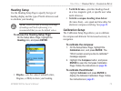
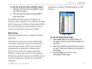
Calendar
Use the calendar to view sunrise and sunset times,
moon phases, hunt and sh probabilities, and archived
waypoints for activities you want to navigate to for
any given day and location.
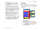
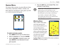
To use the Calendar:
1. Press MENU twice to open the Main Menu.
2. Select the Calendar icon, and press ENTER.
The Calendar Page opens with the current
week shown.
3. Use the ROCKER to highlight the day you
want to add waypoints to, and press ENTER to
show the Page for that day.