


cf Que
™
1620
-30-
GPS Applications
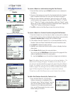
Measure Distance
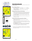
Using the Measure Distance Utility
Measure Distance is a feature that allows you to determine the distance between
two items on the map.
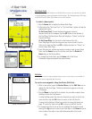
To access Measure Distance:
1. From the Map Page, open the Main Menu and then tap Utilities to
display the Utilities List.
2. Tap Measure Distance to display the Measure Distance Page.
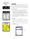
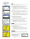
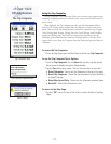
To Measure Distance from your current location:
1. Adjust the map scale to include your current location and the point you
want to measure to. Tap the map scale in the lower left corner of the
map to display the map scale control panel. Select the desired scale.
Or... use the “Zoom Out” tool from the Tool Bar to defi ne an area on
the map and enlarge it.
2. Tap an item on the map and observe the direction and distance in the
fi eld above the Tool Bar.
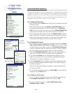
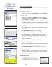
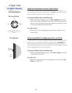
To Measure Distance between two points on the map:
1. Adjust the map scale to include the points you want to measure
between. See Step 1 above.
2. Tap the fi rst item on the map and observe the measurement line con-
necting your current location to the item. Note the Map Pin icon located
behind the Current Position Icon.
3. Tap the Map Pin icon on the Toolbar to move it to the fi rst map item.
Then tap the second map item to measure the distance between the
two. The distance displays in the fi eld above the Tool Bar.
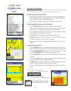
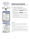
If you don’t want to lose map detail by zooming out in order view both points
on the map, you can tap the Pan Map icon and use the stylus to pan the map to
the second point on the map.
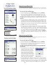
Measure Distance Page
Map Scale Control
Panel
Zoom
In
Measure Between Two Points
Center
Location
Map Scale
Tap to display
Control Panel
Tool Bar Icons
Map
Pin
Pan
Map