


GNS 530(A) Pilot’s Guide and Reference
190-00181-00 Rev. H
SECTION 3
NAV PAGES
3-15
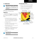
3.5 TERRAIN PAGE
NOTE: GNS 530 units may* display either a
TERRAIN Page or a TAWS Page, (but not both)
depending upon the installed hardware and
configuration.
* Some earlier units are not equipped to support the
TERRAIN and/or TAWS functionality, so therefore will not
have a TERRAIN or TAWS page available.
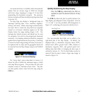
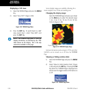
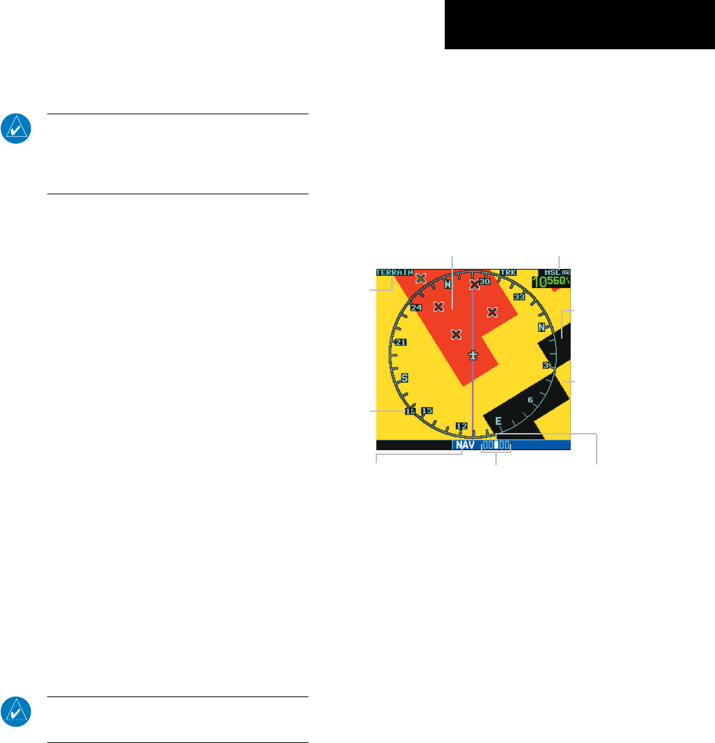
TERRAIN Page
To display the TERRAIN Page, select the NAV Page
Group and turn the small right knob until the TERRAIN
Page is displayed (Figure 3-27). The TERRAIN Page
displays:
• GPS-derived MSL altitude in increments of 20
feet or 10 meters, depending on unit configura-
tion. The ‘G’ to right of the MSL altitude display
reminds the pilot that altitude is GPS-derived.
• Aircraft ground track
• Terrain Range - Indicates the terrain elevation in
colors relative to the aircraft altitude
• Range marking rings - (1 nm, 2 nm, 5 nm, 10 nm,
25 nm, 50 nm, and 100 nm)
• Heading Indicator - The heading indication on the
TERRAIN Page always displays ‘TRK’ for Track-
up, unless there is no valid heading
• Obstacles
• Potential Impact Points
NOTE: See Section 12 for a full description of
TERRAIN functions.
Selectable Display Settings
The TERRAIN Page has two selectable view settings:
• 360˚ View - View from above aircraft depicting
surrounding terrain on all sides (Figure 3-27)
• 120˚ View - View of terrain ahead of and 60˚ to
either side of the aircraft flight path
TERRAIN
Page
Indication
Figure 3-27 TERRAIN Page
GPS-derived
MSL Altitude
Red Terrain (Warning -
Terrain Above or Within
100’ Below Aircraft Altitude)
Number of Pages in
Current Page Group
Position of Current
Page within Current
Page Group
Current Page Group
Display
Range
Black Terrain
(No Danger -
Terrain More
than 1000’ below
Aircraft Altitude)
Yellow Terrain
(Caution - Terrain
Between 100’
and 1000’ Below
Aircraft Altitude)