


GNS 530(A) Pilot’s Guide and Reference
190-00181-00 Rev. H
SECTION 16 – MESSAGES,
ABBREVIATIONS, & NAV TERMS
16-12
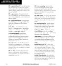
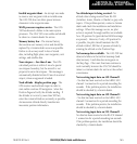
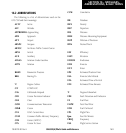
16.3 NAVIGATION TERMS
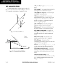
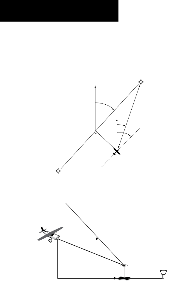
The following navigation terms are used on the GNS
530 and in this Pilot’s Guide. Refer to Figures 15-1 and
15-2 for graphic representation of navigation terms.
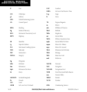
WPT 1
XTK
NORTH
WPT 2
BRG
GS
DIS
AIRPLANE
DTK
TRK
Figure 15-1 Illustrated NAV Terms
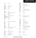
VERTICAL NAVIGATION PROFILE
VERTICAL SPEED REQUIRED
DISTANCE TO TARGET
TIME AND DISTANCE
TO PROFILE
TARGET ALTITUDE
AND POSITION
AIRPORT
CURRENT ALTITUDE
AND POSITION
Vertical
Navigation
Figure 15-2 Illustrated Vertical NAV Terms
ALT (altitude) - Height above mean sea level
(MSL).
BRG (bearing) - The compass direction from the
present position to a destination waypoint.
CAS (calibrated airspeed) - Indicated airspeed
corrected for instrument errors.
CTS (course to steer) - The recommended
direction to steer in order to reduce course error
or stay on course. Provides the most efcient
heading to get back to the desired course and
proceed along the flight plan.
CUM (cumulative) - The total of all legs in a
ight plan (such as ‘cumulative distance’).
DIS (distance) - The ‘great circle’ distance from
the present position to a destination waypoint.
DOP (dilution of precision) - A measure of
satellite geometry quality on a scale of one to ten
(lowest numbers are best, highest numbers are
worst).
DTK (desired track) - The desired course
between the active ‘from’ and ‘to’ waypoints.
EFF (efficiency) - A measure of fuel
consumption, expressed in distance per fuel units
(e.g., nautical miles per gallon).
ENDUR (endurance) - Flight endurance, or total
available flight time based upon available fuel.
EPE (estimated position error) - A measure of
satellite geometry quality and additional factors,
expressed as a horizontal position error in feet or
meters.
ESA (enroute safe altitude) - The
recommended minimum altitude within ten miles,
left or right, of the desired course on an active
flight plan or direct-to.