


GNS 530(A) Pilot’s Guide and Reference
190-00181-00 Rev. H
SECTION 11
VERTICAL NAVIGATION
11-1
SECTION 11: VERTICAL
NAVIGATION (VNAV)
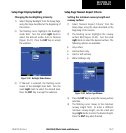
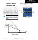
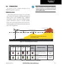
The GNS 530’s Vertical Navigation Page (Figure 11-2)
allows you to create a three-dimensional prole (Figure
11-1) which guides you from your present position and
altitude to a nal (target) altitude at a specied location.
This is helpful when you’d like to descend to a certain
altitude near an airport or climb to an altitude before
reaching a route or direct-to waypoint. Once the prole is
dened, message alerts and additional data on the Default
NAV and Map Pages keep you informed of your progress.
NOTE: To use the vertical navigation features,
the ground speed must be greater than 35 knots
and direct-to navigation or a flight plan must be
activated.
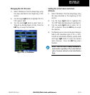
Figure 11-1 VNAV Profile
VERTICAL NAVIGATION PROFILE
VERTICAL SPEED REQUIRED
DISTANCE TO TARGET
TIME AND DISTANCE
TO PROFILE
TARGET ALTITUDE
AND POSITION
AIRPORT
CURRENT ALTITUDE
AND POSITION
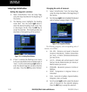
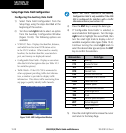
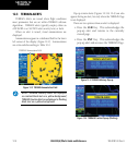
Displaying the Vertical Navigation Page:
Press the VNAV key.
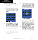
Figure 11-2 VNAV Page
Current Page
Target Altitude and Altitude
Reference (AGL or MSL)
Target Distance
(from reference)
Vertical Speed
Desired
Vertical
Speed
Required