


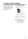

12. USING C-MAP NT MODEL
12-3
R
G
W
R
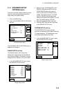
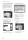
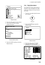
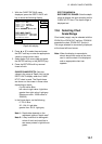
Objects
Navigation mark, fixed
Extended navigational aid, ge
Light
Light
Light
Light
Depth contour
Land area
Source of data
Object windows
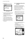
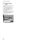
3. Press ▲ or ▼ to select the item desired.
4. Press the [ENTER] key to display
detailed information.
Color
white
Height
7. 00 Meters
Light characteristic
occulting
XXXXXXXX
XXXXXXXX
Navigation mark, fixed
Light.
Sample lighthouse data
5. Press the CANCEL soft key to close the
Objects window.
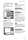
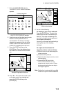
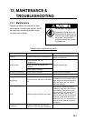
12.3 Tidal Information
The C-MAP NT-FP chart card provides for
calculation of the tide heights for any date.
Additionally it displays the times of sunrise
and sunset.
1. Press the cursor pad to place the cursor
on a Tide icon.
T
Tide icon
2. Press the [ENTER] key to open the
Objects window.
Objects
Depth contour
Caution area
Depth area
Source of data
Tide height
Objects window
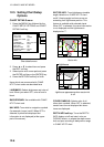
3. Press ▲ or ▼ to select Tide height.
4. Press the ENTER soft key or the
[ENTER] key to open the TIDE window.
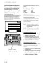
Time: 12:00
Height: 1.01 ft
Draught: 0.82 ft
01/01/00 +01
59 26. 467' N
010 28. 646' E
Port Info
HORTEN
High Water (max) 1.32 ft (13:15)
Low Water (min) 0.32 ft (21:45)
Sunrise 09:15L Sunset 15:27L
0 4 8 12 16 20 24
1.32
1.07
0.82
0.57
0.32
TIDE window