


3. PLOTTER DISPLAYS
3-5
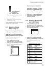
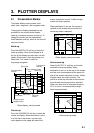
Aid to navigation data
Selected FURUNO and NAVIONICS mini
chart cards can show buoy and lighthouse
data. Simply place the cursor on the
lighthouse or buoy mark.
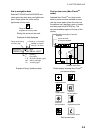
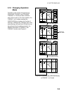
Place the cursor on
a lighthouse or buoy mark.
Placing the cursor on the mark
NAVAID: /FL 6S 12M
FROM OS 52.38nm 48.0°
Period (ex.: 6 seconds)
Visibility in nautical
mile (ex.: 12 miles)
FL : Flashing
F : Fixed light
F FL : Fixed and Flashing light
MO : Morse code light
Oc : Occulting light
Example of data displayed
Range and bearing
from own ship
Example of buoy, lighthouse data
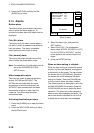
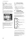
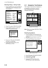
Port service icons (Nav-Charts
TM
cards)
Selected Nav-Charts
TM
mini chart cards
show by icons services available at ports.
Use the cursor pad to place the cursor on
the sailboat icon (denotes a port or harbor),
and then press the [ENTER] key. The
services available appear at the top of the
display.
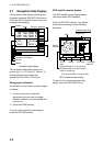
DGPS 3D
CANCEL
NORTH
UP
FIRST AID
Sailboat mark (Port)
Detailed information of service
selected
List of services
at the port selected
Plotter display showing Nav-Charts
TM
port service display
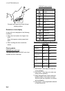
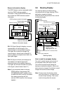
Emergency
medical service
Water
supply station
Customer
service station
Information center
Fueling station
Traveler's
service station
Marine
equipment service
Port
Port service icons