


3. PLOTTER DISPLAYS
3-6
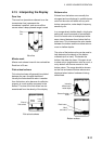
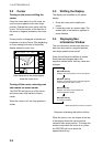
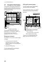
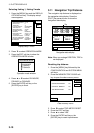
3.7 Navigation Data Display
The navigation data display provide generic
navigation data and DGPS/GPS information.
Press the [PLOT] several times to show the
navigation data display.
DGPS 3D
BEACON
INFO
SAT
INFO
ZOOM
TD
LAT/LON
DATE: JUN 30 2002 TIME 23:59:59
POSITION
34° 56.789' N
135° 56.789' E
RNG
nm
123.25
BRG
299.9°
SPD
kt
12.5
CSE
359.9°
DATUM: WGS-84
LAT
LON
TMP 65.8°F DEP 20.8ft
Range to waypoint
Date
Position
Bearing to waypoint
Geodetic chart datum
Course
Speed
Temperature, depth
TRIP:123nm
Navigation data display
The navigation data display shows your
position by L/L or TD (Loran-C, Decca). To
change position format, press the
appropriate LAT/LON or TD soft key.
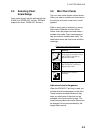
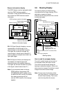
Enlarging an indication
An indication on the screen may be enlarged
as follows:
1. Use the cursor pad to select the
indication which you wish to enlarge.
Selected indication is circumscribed with
a red cursor.
2. Press the ZOOM soft key.
To return to the normal nav data display,
press the RETURN soft key.
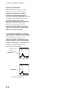
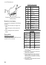
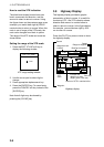
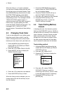
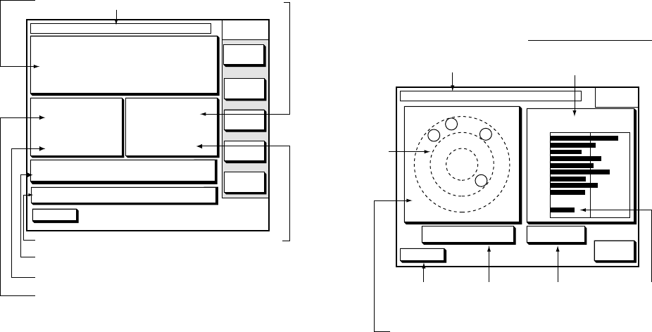
GPS satellite monitor display
The GPS satellite monitor display shows
information about GPS satellites.
Press the SAT INFO soft key. Your display
should look something like the following
illustration.
DGPS 3D
RETURN
SAT
INFO
DATE: JUN 30 2002 TIME 23:59:59
21
07
11
03
06
12
08
05
N
S
EW
30 40 50
21
07
06
11
03
05
12
08
SAT
No.
SNR
ALT 5 m DOP 2.0
20
20
W
123
GPS fix
state
Date
Altitude
DOP value
Estimated position in the sky, and
satellite number in reverse video is
used for positioning.
Receive signal level
Bars show satellite
signal level.
WAAS
satellite*
For WAAS
satellite*
*Only when WAAS fix mode is used.
GPS satellite monitor display
To return to the normal navigation data
display, press the RETURN soft key.