


11. CUSTOMIZING YOUR UNIT
11-2
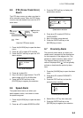
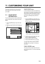
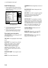
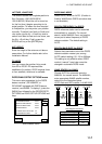
CHART DETAILS menu
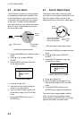
1. Press the [MENU] key followed by the
CHART SETUP OPTIONS and CHART
DETAILS soft keys.
DGPS 3D
CHART
DETAIL
RETURN
EDIT
DEPTH
INFO
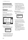
LAT/LON GRID
TEXT INFO
WAYPOINT
WAYPOINT NAME
INDEX
LANDMASS
BACKGROUND
NAV AIDS
SECTOR INFO
OTHER SYMBOLS
MARK SIZE
GREEN
ON
LARGE
ON
ON
BRT YELLOW
BLUE
ON
OFF
WHITE
STD
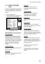
Chart details menu
2. Use the cursor pad to select item and
press the EDIT soft key.
3. Select option with the cursor pad and
press the RETURN soft key to finish.
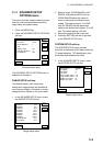
Chart details menu description
LAT/LONG GRID: Turns lat/long grid on/off
and changes its color.
TEXT INFO: Turns geographic name display
on/off.
WAYPOINT: Turns waypoint on or off and
selects size to large or small. “LARGE”
displays waypoint in shape selected;
“SMALL” shows waypoints as an X
regardless of actual shape. “OFF” only
display waypoints when they are used in
navigation.
WAYPOINT NAME: Turns waypoint name
on/off.
INDEX: Turns chart indices on/off.
LANDMASS: Selects brightness and color of
land.
BACKGROUND: Selects background color
to black or blue.
NAV AIDS: Turns aids to navigation symbols
(for example, buoys) on/off. When OFF is
selected, symbols are displayed but
information is not.
SECTOR INFO: Turns lighthouse viewable
angle indication (on FURUNO charts) on/off.
Viewing angle is shown as an arc extending
from lighthouse position. Arc color, white or
green, is the color of the light beam. This
feature is available with selected charts.
OTHER SYMBOLS: Selects color of all
other chart symbols.
MARK SIZE: Selects the mark size STD
(standard) or SMALL (appears with “x”.)
DEPTH INFO soft key: Turns depth info
display on/off and sets it color.