


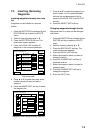

8. NAVIGATION
8-4
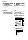
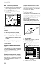
8.4 Following a Route
1. Press the [WPT/RTE] key followed by the
ROUTE soft key to open the route list.
2. Press ▲ or ▼ to select a route.
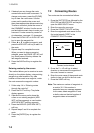
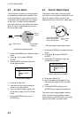
3. Press the GO TO soft key to show the
plotter display.
DGPS 3D
RETURN
WPT
FROM
OS
FISH
1.3 nm
208.5°
ZOOM
IN
ZOOM
OUT
GO TO
WPT
RVSE
ROUTE
GO TO
ROUTE
WP-002
WP-001
FISH
CRAB
Plotter display, route selected as destination
The cursor is on the route waypoint nearest
own ship.
4. Operate the cursor pad to place the
cursor on the waypoint or leg desired in
the route.
5. Press the GO TO WPT or FOLLOW LEG
soft key (depending on the choice made
at step 4).
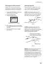
Green lines connect all route waypoints and
arrows on the lines point in the direction to
traverse the route.
Navigate route waypoints in reverse
order
Press the RVSE ROUTE soft key to reverse
the order to traverse waypoints. The arrows
on the route line point in the direction
selected.
Navigate directly to a route waypoint
If you want to go directly to a route waypoint,
place the cursor on the waypoint to show the
flashing diamond, and then press the GO TO
WPT soft key.
Navigate along specific leg of route
Place the cursor on the leg to display it in a
white and red flashing line, and then press
the FOLLOW LEG soft key.
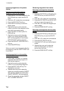
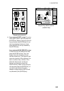
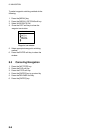
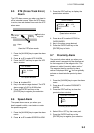
Restarting navigation
When you steer to avoid an obstacle or the
vessel drifts, you may go back your intended
course (Line 1 in the figure below). Use the
steering or highway display to help you
return to course.
Also, if you don’t need to return to the
original course, you can go directly to the
waypoint (Line 2 in the figure below) using
the restart function below.
Original course
Obstacle
Line 1
Line 2
Example of when to restart navigation
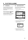
1. Set a destination.
2. Press the [WPT/RTE] key to open the
WAYPOINT & ROUTE menu.
3. Press the LOG soft key.
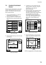
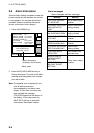
DGPS 3D
LOG
RE-
START
STOP
RVSE
ROUTE
SPEED
ETA 23:59 31.SEP
01
02
03
04
05
BRIDGE
HARBOR
WP<001>
WP<002>
WP<003>
34°23.564'N
135°23.456'E
34°32.456'N
135°32.456'E
34°23.345'N
135°12.456'E
34°34.555'N
135°55.555'E
34°32.555'N
134°99.999'E
LEG
120.5°
23.4nm
23.6°
23.4nm
123.6°
23.5nm
180.5°
23.5nm
180.5°
23.5nm
COORD
TYPE
Estimated Time of Arrival at last
waypoint
Passed waypoint (gray characters)
TO Waypoint (WPT no. in reverse video)
Log display
4. Press the RESTART soft key.