


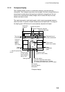

1. OPERATIONAL OVERVIEW
1-19
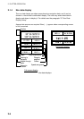
Plotter
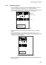
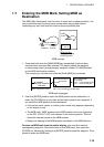
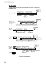
1. Select PLOTTER, then press the EDIT soft key.
PLOTTER
▲
SIMULATION
LIVE
▼
2. Select SIMULATION, then press the [ENTER] knob.
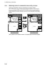
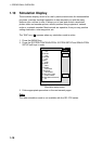
3. Select SPEED, then press the EDIT soft key.
4. Enter speed (setting range, 0-99 kt, default speed, 0 kt) with the
alphanumeric keys, then push the [ENTER] knob.
5. Select COURSE, then press the EDIT key.
6. Select “8 FIGURE” to trace the simulated ship’s track in a figure-eight course,
or enter your own course at DIRECTION. To enter course, use the cursor
pad to select digit, and enter value with the alphanumeric keys.
7. Press the ENTER soft key.
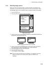
8. Select LATITUDE, then press the EDIT soft key.
9. Enter latitude (setting range, 85
°N-85°S, default setting, 45°35.000’N), then
push the [ENTER] knob.
10. Select LONGITUDE, then press the EDIT soft key.
11. Enter longitude (setting range, 180
°E-180°W, default setting, 125°00.000’W),
then push the [ENTER] knob.
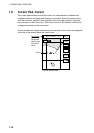
12. Select START DATE & TIME, then press the EDIT soft key.
13. Enter start date and time, then push the [ENTER] knob.
14. Press the [MENU] key to close the menu.