


5. CUSTOMIZING YOUR UNIT
5-19
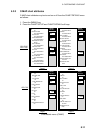
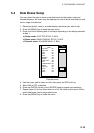
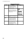
Contents of GPS setup menu
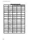
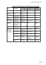
Item Description Settings
Local Time Offset
GPS uses UTC time. If you would rather
use local time, enter the time difference
between it and UTC. Use the +< - ->- soft
key to switch from plus to minus and vice
versa.
-13:30 to +13:30 hours
Geodetic Datum
Geodetic datum is a reference for
geodetic survey measurements consisting
of fixed latitude, longitude and azimuth
values associated with a defined station of
reference. You must have the correct
geodetic datum selected in your plotter so
that it will reference the correct point on
the chart for a given latitude and
longitude. Although WGS-84 is now the
world standard, other categories of charts
still exist. Refer to Appendix for a full list of
geodetic datum.
See Appendix for full
list.
Position Smoothing
When the DOP or receiving condition is
unfavorable, the GPS fix may change
greatly, even if the vessel is not moving.
This change can be reduced by
smoothing the raw GPS fixes. A setting
between 000 to 999 is available. The
higher the setting the more smoothed the
raw data. If the setting is too high, the
response time required to show a change
of latitude and longitude will be too long.
This is especially noticeable if the vessel
is moving fast. Increase the setting if the
GPS fix changes randomly.
0-999 seconds
Spd/Cse
Smoothing
During position fixing, ship’s velocity
(speed and course) is directly measured
by receiving GPS satellite signals. The
raw velocity data may vary too much
depending on receiving conditions and
other factors. You can reduce this random
variance by increasing the smoothing. The
higher the smoothing setting, the more the
raw data will be averaged. If this setting is
high, the response to speed and course
changes will slow. For no smoothing,
enter all zeroes.
0-999 seconds