


v
FOREWORD
A Word to GP-150-DUAL
Owners
Congratulations on your choice of the
FURUNO GP-150-DUAL dual differential
GPS navigation system. We are confident
you will see why the FURUNO name has
become synonymous with quality and
reliability.
For over 50 years FURUNO Electric
Company has enjoyed an enviable reputation
for innovative and dependable marine
electronics equipment. This dedication to
excellence is furthered by our extensive
global network of agents and dealers.
This equipment is designed and constructed
to meet the rigorous demands of the marine
environment. However, no machine can
perform its intended function unless operated
and maintained properly. Please carefully
read and follow the recommended
procedures for operation and maintenance.
We would appreciate hearing from you, the
end-user, about whether we are achieving
our purposes.
Thank you for considering and purchasing
FURUNO equipment.
Features
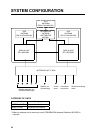
The GP-150-DUAL consists of two dual
differential GPS navigator systems and an
interface unit. Each GPS navigator consists
of a display unit combining a GPS receiver
and video plotter, a GPS antenna. The
interface unit functions to exchange data
between the GPS navigators and external
equipment. A high sensitivity receiver tracks
up to 12 satellites simultaneously. An 8-state
Kalman filter ensures optimum accuracy in
determination of vessel position, course and
speed.
The main features of the GP-150-DUAL are
• Comprehensive navigation data displays
• Storage for 999 waypoints and 30 routes
• Alarms: Waypoint Arrival, Anchor Watch,
Cross track Error, Speed, Water
Temperature, Depth, and Trip
• Man overboard feature records latitude and
longitude coordinates at time of man
overboard and provides continuous
updates of range and bearing to that point.
• Menu-driven operation
• Bright 122 x 92 mm LCD with temperature
compensated tone and brilliance
adjustment
• Power consumption is a low 10 W per
navigator.
• Connection of autopilot (option) - steering
data output to autopilot
• Digital display of water temperature and
depth with connection of echo sounder
having IEC 61162-1/NMEA input
• Memory stores 2,000 points of track and
marks.
• 3D "Highway" display shows ship's track
overlaid on intended course.
• Position may be shown in latitude and
longitude or LOP (Loran or Decca).
• Navaid information (lighthouse data, lighted
buoys, etc.) can be displayed by
downloading database from personal
computer.
• Fully meets the following regulations:
IMO MSC. 112(73), IEC 61162-1 and IEC
61108-1.
Program No.
2051518-01.xx (January, 2006)