


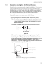
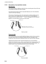
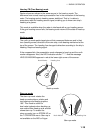

1. RADAR OPERATION
1-14
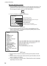
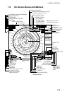
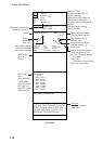
Guidance Box
ARP, AIS Functions Box
GUARD ALARM, TIMER ALARM, GUARD ZONE,
LOST TRGT, CPA/TCPA, TARGET FULL(AUTO),
TARGET FULL(MAN), AZIMUTH, HEAD LINE,
TRIGGER, VIDEO, GYRO, LOG, EPFS, XTE,
ARRIVAL WPT, DEPTH,RECEIVE, other
ARP TARGET
No. 42
BRG 25.5°T
RNG 3.4NM
T CSE 264.0°T
T SPD 12.3KT
CPA 2.9NM
TCPA 12.2MIN
BCR 1.7NM
BCT 20MIN
20
40
60
80
100
-30 20 10
DEPTH 22.30 m WIND 15.4 m/s
HDG
242.2°T
SPD
9.9kt BT
SB
0.1kt
COG
30.2°T
SOG
10.2.2kt
OS POSN
34°40.00N
135°24.00E
DGPS
45.1°T
Wind Speed and Angle
(True or Relative angle)
Electronic Position-fixing
System and position*
Heading is TRUE
(variation-corrected gyro or
magnetic heading)
Speed data is LOG, MAN, etc.,
showing sensor and types.
CSE when water tracking mode is
selected.
STW when water tracking
mode is selected.
ARP Target
Data
(See Chapter 3.)
* GPS, DGPS,
PPS, RTK, FRTK,
DR. PPS, RTK
and FRTK require
GGA sentence.
Tide relative to North,
full scale 10 kt
Wind direction relative to
own ship heading, full
scale 100 kt.
S
WE
N
Depth
Depth
Echogram
(See 1.40.)
Alert Box
(Warnings and Alert
Messages)
Current speed and direction
Water temperature, TTG*,
WPT no., range and bearing
to waypoint
Date, time
* TTG shown as "00:00" when
there is no cursor data.
CURRENT 2.3kt 69.9
°R
TEMP 16°C TTG 00:00:00
WPT001 6.5NM 35.2°R
DATE OCT/25/03 10:00 UTC
ARP Target
Data (or
Zoom)
Zoom display appears
in nav data box when
nav data is turned off.
WT
MAN
GPS
Data fields