


5. VIDEO PLOTTER OPERATION
5-3
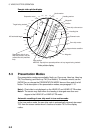
5.4 Radar Map
A radar map is a combination of map lines and symbols whereby the user can
define and input the navigation data, route planning and monitoring data.
The radar map may contain 20,000 points of data. The map data can be
memorized to facilitate repeated use on a routine navigation area.
The user can create a radar map on-real time while using the radar for
navigation or at leisure time at anchor or while the radar is not being used. Place
of a map can be made for any waterways apart from the actual own ship
location.
All radar map functions are accessed from the radar display. To choose the radar
display, use the trackball to choose the DISPLAY MODE box and push the left
button to display “RADAR.” Then, follow the procedures in this section to create
a radar map.
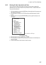
5.4.1 Turning on the radar map display
1. Roll the trackball to choose the MARK box.
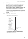
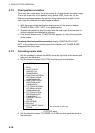
2. Push the right button to open the MARK menu.
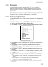
[MARK MENU]
1 ORIGIN MARK STAB
GND/SEA
2 MARK KIND
ORIGIN MARK(No. )/
ORIGIN MARK(SYM)/
MAP MARK/
WP 1~50/
WP 51~ 100/
WP 101~150/
WP 151~ 200/
OWN SHIP SHAPE
8 MARK POSN
CURSOR/OS/L/L
00°000.00 N
000°000.00 E
9 MAP DISPLAY
OFF/ON
0 MAP MARK COLOR*
RED/GRN/BLU/YEL/
CYA/MAG/WHT
* Not available on IMO
or A type
MARK menu
3. Roll the wheel to choose 9 MAP DISPLAY and then push the wheel.
4. Roll the wheel to choose ON and then push the wheel or the left button.
5. Push the right button to close the menu.