


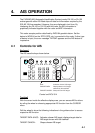

4. AIS OPERATION
4-9
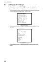
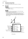
4.7.2 Detailed target data
1. Roll the trackball to place the cursor on the desired AIS target in the data box
at the right side of the screen.
2. Push the left button to show detailed data.
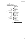
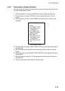
[EXPANDED DATA]
NAME:
VOYAGER
CALL: 143678
LAT: 34
°
44.2345'N
LON: 135
°
32.1890'E
POS. SNS:
GPS
POS. ACC.: HIGH
NAV. STATE: ANCHOR
MMSI No.: 107374182
IMO No.: 12354876
SHIP LENGTH: 187m
SHIP WIDTH: 28m
SHIP DRAFT: 12.2m
DESTINATION
Osaka
ETA: 01/FEB 12:59
AIS VERSION: 0
FUSION: OFF
TYPE OF SHIP
& CARGO TYPE:
DREDGING OR UNDER
WATER OPERATION
Ship's name
Call sign
Latitude
Longitude
Position fixing device
Position accuracy (HIGH, LOW)
Navigation status
MMSI No.
IMO No.
Length
Width
Draft
Destination
Estimated Time of Arrival
AIS program no.
Fusion ON/OFF
Type of ship and cargo
Expanded data