


5. VIDEO PLOTTER OPERATION
5-10
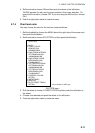
5.7.2 Chart position correction
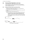
There may be a case where the chart overlay is not aligned with the radar image.
This is due to an error in the position fixing system (GPS, Loran, etc.) or the
different coordinates between the position fixing system and the radar. In this
case, align the chart with the radar image as below.
1. With the cursor inside the effective display area, roll the wheel to display
“CHART ALIGN L=OFF / EXIT” in the guidance box.
2. Operate the trackball to align the chart with the radar map. Note that track is
neither recorded nor displayed at this point.
3. Push the left button to set. “CHART ALIGN” appears (in red) at the right side
of the screen.
To release the chart position correction, display “CHART ALIGN L=OFF /
EXIT” in the guidance box and then push the left button until “CHART ALIGN”
disappears from the screen.
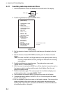
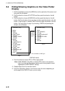
5.7.3 Correcting cursor data
1. Roll the trackball to choose the MENU box at the right side of the screen and
then push the left button.
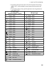
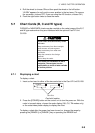
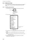
2. Roll the wheel to choose 5 PLOTTER and then push the left button.
[PLOTTER]
1 BACK
2 CHART COLOR*
GRN/YEL/CYA
ORANGE/GRAY
3 OWN TRACK INTERVAL
OFF/DRAW/10S/30S/
1M/2M/3M/6M/15M
4 OWN TRACK COLOR
RED/GRN/BLU/YEL/
CYA/MAG/WHT
5 TGT TRACK INTERVAL*
OFF/DRAW/10S/30S/
1M/2M/3M/6M/15M
6 TGT TRACK COLOR*
RED/GRN/BLU/YEL/
CYA/MAG/WHT
7 CURSOR L/L ALIGN
OFF/ON
8 [DATA ERASE]
9 [DISPLAY]
0 AUTO TARGET TRACK*
OFF/ON
* Not available on IMO type
PLOTTER menu
3. Roll the wheel to choose 7 CURSOR L/L ALIGN and then push the wheel or
the left button.