


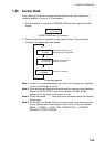

1. RADAR OPERATION
1-85
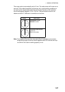
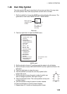
1.45 Cursor Data
Cursor data can be shown in range and bearing from own ship, latitude and
longitude position or cursor’s X-Y coordinates.
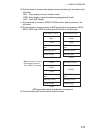
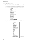
1. Roll the trackball to choose the CURSOR DATA box at the right side of the
display.
+
34°40.849 N
135°18.303 E
CURSOR DATA box (L/L position)
2. Push the left button to choose the cursor data to show. The cursor data
changes in the sequence shown below.
+
34°30.323 N
135°08.263 E
+
9.649NM
9.683NM
+
1351.2°T
13.67NM
Range and bearing from
own ship to cursor position
Latitude and longitude
position of cursor
Cursor X-Y position
Cursor data options
Note 1: For the X-Y coordinates display, the Y-axis is the heading line, right/top
is “plus” and left/lower is “minus.”
Note 2: When displaying latitude and longitude position and the cursor has been
aligned (on the PLOTTER menu), the indication “CHART ALIGN”
appears at the right side of the screen (in red).
Note 3: Cursor data reads “- - -.-” when the cursor is placed outside the effective
display area.
Note 4: For the IMO- and A-type radars, uou may choose cursor bearing format
(true or relative) and cursor range unit (nm, sm, km or kyd) as follows:
MENU → 2 MARK → 9 [EBL, VRM, CURSOR SET] → (CURSOR
BEARING, CURSOR RANGE)