


54
PUBX, 00 – Latitude/Longitude Position Data
Output message. This message transmits navigation data defined in the local geodetic
frame.
$PUBX,00,p00x1,p00x2,p00x3,p00x4,p00x5,p00x6,p00x7,p00x8,p00x9,p00x10,p0
0x11,p00x12,p00x13,p00x14,p00x15,p00x16,p00x17,p00x18,p00x19*hh<CR><LF
>
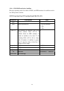
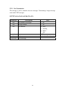
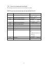
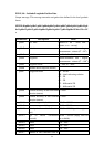
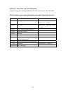
Parameters Descriptions Notes
p00x1 UTC time hhmmss.ss: hh – hour; mm –
minute; ss.ss – second
p00x2 Latitude ddmm.mmmmm: dd – degree;
mm.mmmmm – minute (0
o
~ 90
o
)
p00x3 Latitude sector N – North; S – South
p00x4 Longitude dddmm.mmmmm: ddd – degree;
mm.mmmmm – minute (0
o
~ 180
o
)
p00x5 Longitude sector E – East; W – West
p00x6 Altitude above ellipsoid (meters)
p00x7 Navigation mode NF – not fix
DR – dead reckoning solution
G2 – 2D
G3 – 3D
D2 – differential 2D
D3 – differential 3D
p00x8 Position accuracy in the horizontal
direction (meters)
0 ~ 9999
p00x9 Position accuracy in the vertical
direction (meters)
0 ~ 9999
p00x10 Speed over ground (km/hr) -999.99 ~ 999.99
p00x11 Course over ground (degrees) 000.00 ~ 359.99
p00x12 Velocity in the vertical direction
(m/s)
-999.99 ~ 999.99 (positive: up)
p00x13 Age of DGPS corrections
(seconds)
000.00 ~ 999.99 (empty field for
not available)
p00x14 HDOP 00.0 ~ 99.9
p00x15 VDOP 00.0 ~ 99.9
p00x16 GDOP 00.0 ~ 99.9
p00x17 Number of GPS satellites used in