


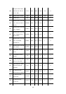
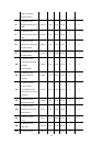
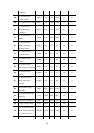
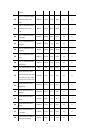

142
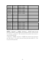
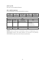
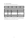
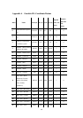
Appendix A Geodetic ID: Coordinate Datum
Index Name Acron
y
m DX (m) DY(m) DZ (m)
Ellipsoid
Index (See
below)
Rotation
and Scale
(See
below)
0
World Geodetic System -
84
WGS 84 0.0 0.0 0.0 0 0
1
World Geodetic System -
72
WGS 72 0.0 0.0 4.5 23 1
2
Earth-90 - GLONASS
Coordinate system
ETH 90 0.0 0.0 4.0 8 0
3
Adindan - Mean Solution
(Ethiopia & Sudan)
ADI-M -166.0 -15.0 204.0 7 0
4
Adindan - Burkina Faso ADI-E -118.0 -14.0 218.0 7 0
5
Adindan - Cameroon ADI-F -134.0 -2.0 210.0 7 0
6
Adindan - Ethiopia ADI-A -165.0 -11.0 206.0 7 0
7
Adindan - Mali ADI-C -123.0 -20.0 220.0 7 0
8
Adindan - Senegal ADI-D -128.0 -18.0 224.0 7 0
9
Adindan - Sudan ADI-B -161.0 -14.0 205.0 7 0
10
Afgooye - Somalia AFG -43.0 -163.0 45.0 21 0
11
ARC 1950 - Mean
(Botswana, Lesotho,
Malawi, Swaziland,
Zaire, Zambia,
Zimbabwe)
ARF-M -143.0 -90.0 -294.0 7 0
12
ARC 1950 - Botswana ARF-A -138.0 -105.0 -289.0 7 0
13
ARC 1950 - Burundi ARF-H -153.0 -5.0 -292.0 7 0
14
ARC 1950 - Lesotho ARF-B -125.0 -108.0 -295.0 7 0
15
ARC 1950 - Malawi ARF-C -161.0 -73.0 -317.0 7 0
16
ARC 1950 - Swaziland ARF-D -134.0 -105.0 -295.0 7 0
17
ARC 1950 - Zaire ARF-E -169.0 -19.0 -278.0 7 0