


6
•••••••••••••••••••••••••••••••••••••••••••••••••••••••••••••••••••••••
Introduction
••
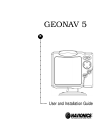
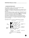
INTRODUCTION
The GEONAV 5 is a graphic GPS plotter that displays your
boat’s current position with respect to an electronic chart.
The GEONAV 5 can use up to 12 satellites simultaneously.
By using a GEONAV 5 and a NAVIONICS electronic chart you
will never get lost even in bad weather conditions such as fog
or rain because your plotter will always display where you are
and where your are heading to!
The ROUTE function will allow you to plan a trip. NAVIONICS
chart cartridges are available for all busy boating areas
around the world and can be used in addition to your official
paper charts. NAVIONICS chart cartridges are available from
NAVIONICS authorized dealers and outlets around the world.
See your local marine electronics dealer for more information.
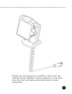
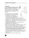
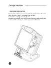
The GEONAV 5 unit is equipped with accessories for
installation in your boat and car.
The GEONAV 5 can be used also for land applications: the
GPS receiver and the new NAVIONICS land charts will allow
displaying easily your position with respect to the most
popular roads and city names. The installation of the
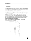
GEONAV 5 in your car takes only a few seconds: just position
the plotter on the dashboard with the proper bracket and fix
the suction cup to the front window, then connect the power
cable to the lighter. Enjoy your trip!